Fine Antique Maps & Engravings
from the 16th to the 19th centuries
Quick search:

Advanced search
Cartographer index
Your basket:
0 items
£0.00
View basket
All stock
Sort results by: Most recently added Cartographer A-Z Year printed Price, lowest to highest Price, highest to lowest Region
Map of the Austrian Province of Carinthia
Johann Baptist Homann.

Nuremberg, c.1720. Map of Carinthia in the Austrian Alps, with a propect of Klagenfurt and two other vignette scenes.
HOMA0066
£390.00

More details


Prospect of Vienna
Millar.

London, c.1785. A prospect of the Austrian city of Vienna, capital of the Germanic 'Holy Roman Empire'. Engraved by Hawkins for 'Millar's New Complete & Universal System of Geography'.
MILL0003
£69.00

More details


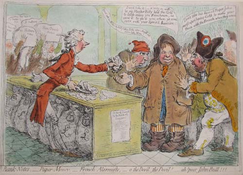
Caricature of Pitt's new Banknotes.
James Gillray.

London, H.G.Bohn, 1851. Because of the need for gold for foreign trade during the war with the French, William Pitt the younger pressured the Bank of England into temporarily suspending its practice of honouring banknotes with gold. The Bank then issued £1 & £2 notes for the first time. Here Sheridan, Fox and Stanhope, dressed as French revolutionaries, try to persuade John Bull to refuse to accept them. First published 1797.
GILL0008
£250.00

More details


Map of Bedfordshire from the Britannia
Richard Blome.

London, 1673. Published in Blome's 'Britannia'.
BLOM0005
£175.00

More details


An early 18th century distance table of Bedfordshire's towns
Thomas Cox.

London: Elizabeth Butt et al, 1720. A triangular distance table of Bedfordshire, with the arms of the City of Bedford and some statistics about the county.
COXA0013
£45.00

More details


Miniature county map of Bedfordshire
William Lewis.

London: P. Martin, 1819. From 'Lewis's New Traveller's Guide', marking cities, market towns, seats, mail coach roads & turnpikes.
LEWI1038
£25.00

More details


Map of eastern Belarus
Homann Heirs.

Nuremburg: Homann Heirs, 1775. Map of eastern Belarus, including the the counties of Vitebsk, Polotsk and Mstislavl, seized three years earlier by the Russians in the First Partitiion of Poland. Marking the Dnieper and Dwiner rivers, with the towns of Polack, Orsha & Mogilev. Over the borders are Smolensk in Russia and Kiev in Ukraine.
HOMA1035
£450.00

More details


Map of Belgium
Emanuel Bowen.

London, c.1745. Published for 'Mr Tyndal's Continuation of Mr Rapin's History' [of England], with a decorative title cartouche.
BOWE0001
£120.00

More details


Decorative map of Belgium
John Tallis.

London Printing and Publishing Company, c.1860. With inset vignettes including views of Antwerp Cathedral and the Monuments on the Plains of Waterloo.
TALL0052
£79.00

More details


Hansiatic League Headquarters in Antwerp
Matthaus Merian.

Frankfurt, c1660. The Hansiatic League Headquarters in Antwerp.
MERI0013
£95.00

More details


Map of Antwerp with fortifications
Eugène Henri Fricx.

Brussels, 1711-12. A fine impression of this plan of Antwerp, highlighting the fortifications and showing the important buildings in profile. An inset shows the environs of the city.
FRIC0001
£390.00

More details


Townplan of Antwerp
Christoph Weigel.

Nuremburg, 1718. Detailed townplan, with an inset of the environs.
WEIG0024
£290.00

More details


Brussels
Society for the Diffusion of Useful Knowledge.

London: Baldwin & Cradock, 1837. Detailed map of Bruxelles, with an inset map of the environs.
SDUK0006
£60.00

More details


Plan of the Battle of Maastricht, 1703
Isaac Basire.

London, 1745. Fought in the War of the Spanish Succession. 'D'Auverquerque' is the Dutch General Ouwerkerk, ally of Marlborough against the French. Engraved by Basire for 'Mr. Tindal's Continuation of Mr.Rapin's History of England'.
BASI0006
£185.00

More details


Cook's Voyage through the Bering Straits
Benard.

Paris, c.1785. Captain James Cook's third and final expedition was sent to try to find the North West Passage from the Pacific. The ship sailed though the Bering Straits to be blocked by the icewall. Turning south they sailed to Hawaii where Cook was killed. Published in a French account of Cook's Voyages.
BENA0007
£175.00

More details


Cook's Map of the Bering Straits.
Alexander Hogg.

London: Hogg, c.1785. The purpose of Cook's Third Voyage was to discover the North West Passage. Having discovered Hawaii in January 1778 he sailed up the eastern coast of America and passed through the Bering Straits, where he was blocked by the Arctic icewall. He returned to Hawaii in 1779, where he was killed, after which his crew went north for a second attempt to breach the icewall, again failing before returning to England.
HOGG0006
£125.00

More details


View of Cook's crew shooting Walruses.
Capt. James Cook.

London, Alexander Hogg, c.1790. From 'Anderson's Large Folio Edition of the Whole of Capt.n Cook's Voyages &c Complete'.
COOK0016
£95.00

More details


Miniature map of Berkshire
Pieter van den Keere.

London, 1627. The so-called 'miniature Speed' map, with an English text on reverse.
KEER0003
£125.00

More details


An early 18th century distance table of Berkshire's towns
Thomas Cox.

London: Elizabeth Butt et al, 1720. A triangular distance table, with the arms of four towns, including Windsor, and some statistics about the county.
COXA0002
£80.00

More details


Miniature county map of Berkshire
William Lewis.

London: P. Martin, 1819. From 'Lewis's New Traveller's Guide', marking cities, market towns, seats, mail coach roads & turnpikes.
LEWI1020
£35.00

More details