Fine Antique Maps & Engravings
from the 16th to the 19th centuries
Quick search:

Advanced search
Cartographer index
Your basket:
0 items
£0.00
View basket
Asia > Central Asia
Sort results by: Most recently added Cartographer A-Z Year printed Price, lowest to highest Price, highest to lowest Region
Ptolemiac map of Central Asia
Girolamo Ruscelli.

Venice, 1562. Map of Central Asia after Claudius Ptolemy of Alexandria (c. AD 90-168). covering the area of modern Iran, Turkmenistan, Uzbekistan, Kasakhstan, Afghanistan, Kashmir, etc. 'Turris Lapidea' (Tower of Stone) is believed to be Tashkent.
RUSC0025
£125.00

More details


Map of Central Asia
Rigobert Bonne.

Paris, c.1780. Central Asia from the Persian Gulf to Bhutan, marking Bahrain, the Caspian Sea, Afghanistan, Bukhara and Tibet.
BONN0036
£85.00

More details


Map of the Sri Lankan island Manaar
Philip Baldeaus.

London: A. & J. Churchill, c.1750. The island of Mannar, off the north-west of Sri Lanka, with its Dutch fortress. The fort was built by the Portuguese in 1650, taken over first by the Dutch in 1650 and then by the British in 1795. Baldeaus, a Dutch missionary in the Malabar and Coromandel Districts, wrote about the Dutch settlements in Southern India.
BALD0001
£250.00

More details


Detailed map of India at the beginning of the 18th century
Pieter van der Aa.

Leiden, c.1710. Map of India with a title cartouche full of images.
AAAA0019
£225.00

More details


Early plan of Tharangambadi, Tamil Nadu
Jacques Nicolas Bellin.

Paris, 1752. Decorative plan of Tharangambadi or Tranquebar, on the Coromandel coast. Founded by the Danish East India Company in1620, the colony was sold to Britain in 1845.
BELL0181
£125.00

More details


India
Charles Smith.

London, c.1808. Detailed map of British India.
SMIT0001
£59.00

More details


Map of Northern India, Bangladesh and the Himalayan Kingdoms
John Tallis.

London, J. & F. Tallis, c.1851. Northern India, with Nepal, Sikkim and Bhotan. Drawn and engraved by Rapkin, with six vignettes including a view of a tiger hunt.
TALL0055
£125.00

More details


Map of Coromandel
Thomas Bowen.

London: J.Harrison, 1788. Detailed map of Coromandel, on India's east coast, marking Madras.
BOWE1001
£98.00

More details


Plan of the Portuguese city of Goa
Matthaus Merian.

Frankfurt, c.1638. Early plan of Goa, based on that of Linschoten published 1596. With a 43-point key.
MERI0016
£390.00

More details


View of Surat in Gujarat
Churchill.

London, c.1746. Surat, the trading city in Gujerat. Published in 'Churchill's Voyages'.
CHUR0006
£125.00

More details


Natives of Malabar
Churchill.

London, c.1746. Engraved by vander Gouwen for an edition of 'Churchill's Voyages'.
CHUR0001
£39.00

More details


Miniature Map of Southern India
Petrus Bertius.

Amsterdam, Jodocus Hondius, 1616, First edition. Hondius engraved new plates for his edition of the Bertius atlas 'Tabularum Geographicarum Contractarum', which he sold alongside the Mercator 'Atlas Minor'.
BERT0086
£140.00

More details


Northern India
Jacques Nicolas Bellin.

Paris, 1752. Northern India & Pakistan with parts of Afghanistan & Bangladesh.
BELL0167
£125.00

More details


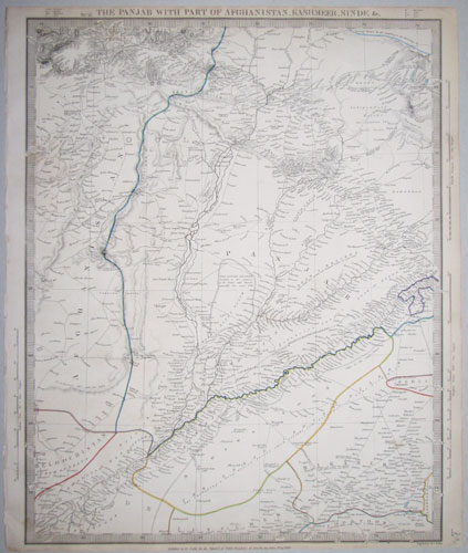
The Punjab during the First Anglo-Afghan War
Society for the Diffusion of Useful Knowledge.

London, SDUK, 1839. Detailed map, of the borders between modern Afghanistan, India and Pakistan. On importance is the Khyber Pass, the main link between British India and Afghanistan , at a time when the 'Great Game' had evolved into the disasterous First Anglo-Afghan War, 1838-1842.
SDUK0073
£125.00

More details


Unusual map of the Environs of Basra, Iraq.
Olfert Dapper.

Amsterdam, J. van Meurs, 1680. From Dapper's 'Naukeurige beschryving van Asie', shortly after the area was captured by the Ottoman Empire in 1668.
DAPP0004
£175.00

More details


Chart of the Northern Mariana Islands.
Jacques Nicolas Bellin.

Paris, c.1752. Chart of the Northern Mariana Islands, with an inset of Guam.
BELL0141
£95.00

More details


Plan of Hormuz at the mouth of the Persian Gulf
Jacques Nicolas Bellin.

Paris, c.1748. Plan of Hormuz at the mouth of the Persian Gulf, within a decorative engraved border.
BELL0154
£175.00

More details


Decorative map of Sri Lanka
Guillaume De L'Isle.

Amsterdam, Covens & Mortier, c.1730. A large and colourful map of Sri Lanka, with rococo cartouches for title and scale.
DELI0001
£680.00

More details


Detailed map of playing fields of the Great Game
John Tallis.

London, the London Printing and Publishing Company, 1861. Showing parts of Kazakhstan, Uzbekistan & Turkestan, markin Bukhara, Samarkand and Tashkent, with engraved vignette scenes of Tartar nomadic life. The 'Great Game' was the name for the Anglo-Russian rivalry in Central Asia, with Russia pushing south to threaten British India through Afghanistan. At the time this map was published the Crimean War and the India Mutiny had made the Game more intense. Less than a decade later Independent Tartary had gone: Tashkent was annexed by Russia in 1865, and Samarkand & Bukhara came under Russian control in 1868.
TALL0048
£140.00

More details


Early map of Tibet
Jacques Nicolas Bellin.

Amsterdam, c.1750. Engraved by Schley for a Dutch edition of Prevost's 'Histoire Generale des Voyages'.
BELL0157
£195.00

More details


 1