Fine Antique Maps & Engravings
from the 16th to the 19th centuries
Quick search:

Advanced search
Cartographer index
Your basket:
0 items
£0.00
View basket
Europe > Italy
Sort results by: Most recently added Cartographer A-Z Year printed Price, lowest to highest Price, highest to lowest Region
Townplan of Genova
Genoa. (Genova.)
Society for the Diffusion of Useful Knowledge.

London: Baldwin & Cradock, 1834. Detailed plan, with elevations of the important buildings under the map.
SDUK0047
£60.00

More details


Milan map
Les Environs de Milan.
Nicolas De Fer

Paris, 1705. Map of the environs of Milan, with the defensive walls of the city shown.
DEFE0036
£195.00

More details


Townplan of Milan
Milan. (Milano.)
Society for the Diffusion of Useful Knowledge.

London: Baldwin & Cradock, 1832. Detailed plan, with elevations of the important buildings under the map.
SDUK0045
£60.00

More details


Townplan of Naples
Naples. (Napoli.)
Society for the Diffusion of Useful Knowledge.

London: Baldwin & Cradock, 1835. Detailed plan, with two prospects under the map.
SDUK0044
£125.00

More details


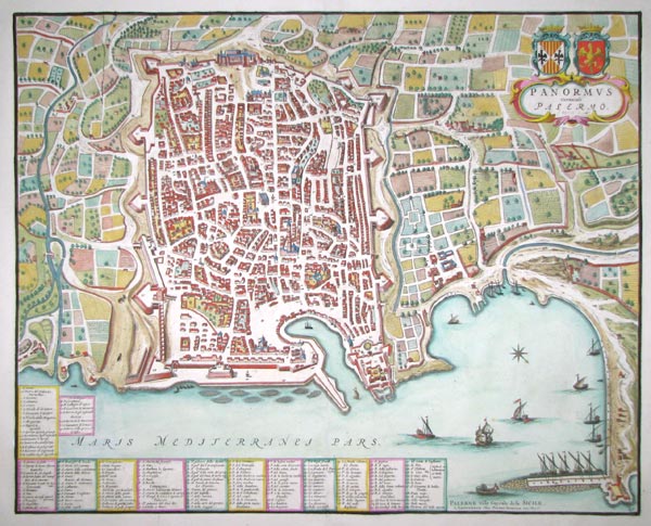
An uncommon town plan of Palermo
Panormus Vernacule Palermo.
Johannes Blaeu.

Amsterdam, Pierre Mortier, 1705. An uncommon map-view of Palermo in Sicily, with an extensive 162-point key. In 1663 Johannes Blaeu published his three-volume 'Townbooks of Italy', with this map appearing in the third volume, which focused on the Kingdom of Naples and Sicily. After Blaeu's death and the disastrous fire at his publishing house, the plates for the atlas were bought by Pierre Mortier, who added his own maps to the series and republished it as a four-volume set.
BLAE0112
£980.00

More details


Plan of the defences of Messina in Sicily
Plan of the Works of the City of Messina, one of the strongest and most considerable Cities of Sicily, and a fine Sea-Port.
Isaac Basire.

London, 1745. Engraved by Basire for 'Mr. Tindal's Continuation of Mr.Rapin's History of England'.
BASI0007
£275.00

More details


Townplan of Syracuse
Syracuse with the Remaining Vestiges of the Five Cities.
Society for the Diffusion of Useful Knowledge.

London: SDUK, 1939. Detailed plan, with a prospect under the map.
SDUK0048
£50.00

More details


Chart of the Bay of Agrigento in Scicily
The Gulf of Gargente in Sicily.
Joseph Roux.

London. c.1805. From an English edition of Roux's sea atlas of port plans.
ROUX0005
£49.00

More details


Map of the Tyrol
Principali Dignitate Gaudens Comitat Tirolis...
Georg Matthaus Seutter.

Augsburg, c.1750. The mountainous borders of Italy, Switzerland & Austria, with an allegorical title cartouche lower right.
SEUT0023
£295.00

More details


Tyrol
Le Tyrol...
Didier Robert de Vaugondy.

Paris, 1753. Map of the Tyrol, divided between Italy and Austria.
ROBE0027
£180.00

More details


 1