Fine Antique Maps & Engravings
from the 16th to the 19th centuries
Quick search:

Advanced search
Cartographer index
Your basket:
0 items
£0.00
View basket
All stock
Sort results by: Most recently added Cartographer A-Z Year printed Price, lowest to highest Price, highest to lowest Region
Map of South East England
Le Provincie che sono al Sud Est Dell'Inghilterra.
Bartolomeo Borghi.

Siena: Pazzini Carli, c.1790. An uncommon map South East England, showing west to Hampshire and north to Bedfordshire.
BORG0003
£125.00

More details


Large map of Western Europe in the Dark Ages.
Germany, France, Italy, Spain, British Isles, In an intermediate Century between Antient and Modern Geography.
Jean Baptiste Bourguigon d'Anville.

London: Laurie & Whittle, 1794. Westen Europe after the Fall of the Roman Empire.
ANVI0002
£350.00

More details


Limehouse, London view
A View taken near Limehouse Bridge, looking down the Thames.
John Boydell.

London, c.1795. Originally published in 1751, this example comes from a compilation volume issued when Boydell became Lord Mayor of London.
BOYD0001
£395.00

More details


World on Mercator's Projection
Il Mappamondo o sia Descrizione Generale del Globo Ridotto in Quadro.
Antonio Zatta.

Venice, 1795. The world on Mercator's Projection. Despite the date of 1795 and the inclusion of the route taken by Cook in his first circumnavigation, the coastlines of New Zealand and the Bering Straits have not been corrected.
ZATT0052
£490.00

More details


Unusual map of Asia
Asie.
Vosgien.

France, 1800. Asia, with a large island of 'Jedso' above Japan. The Cape York Peninsula joins Australia to New Guinea.
VOSG0005
£98.00

More details


Allegorical print of Geography
Minerva instructing Britannia in the Science of Geography: In the foreground are allegorically represented the four Quarters of the World...
W.H. Brown

London, C.Cooke, 1801. A circular scene of the Four Continents, Minerva and Britannia, with a border surmounted by a figure of Neptune, with medals with the names of famous explorers from Magellan and Drake to Anson, Cook and La Perouse. Engraved by R. Woodman after a design by W.H. Brown.
BROW0002
£49.00

More details


Map of South America
South America.
John Walker.

London, 1801. Published in 'Walker's Geography'.
WALK0003
£75.00

More details


A map of the world's mountain ranges
Map of the World Exhibiting the Principal Features, in Natural Geography.
Cooper.

London: Sherwood, Neely & Jones, 1809. A map showing the mountain ranges, including Rennell's infamous 'Mountains of Kong' in Africa.
COOP0001
£95.00

More details


Scandinavia
Scandinavia.
John Pinkerton.

London, Cadell & Davies, 1809. Large and detailed map of Scandinavia, with strong original colour.
PINK0009
£125.00

More details


A Turner Landscape of the River Clyde.
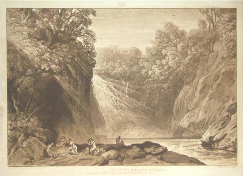
Clyde. In the Possession of J.M.W.Turner.
J.M.W. Turner,

London, Charles Turner, 1809. Women bathing under a waterfall on the Clyde, the river that flows through Glasgow, Scotland's most important maritime city. Published in Turner's 'Liber Studorum', a collection of views by the English master of landscape, with plates engraved by Charles Turner (no relation).
TURN0002
£225.00

More details


Miniature county map of North Wales
North Wales.
William Lewis.

London: P. Martin, 1819. From 'Lewis's New Traveller's Guide', marking cities, market towns, seats, mail coach roads & turnpikes.
LEWI1022
£30.00

More details


Map of Tartary
Chinese and Independent Tartary.
John Cary.

London, c.1830. A colourful map of Central Asia from the Caspian Sea to Manchuria, including Mongolia, Tibet and Bokara.
CARY0023
£95.00

More details


View of the Pool of London
The Pool of London. 1834.
J.D. Harding.

London, c.1835. A scene of the traffic on the Thames.
HARD0001
£250.00

More details


Detailed map of South Africa
South Africa Compiled from the M.S. Maps in the Colonial Office, Capt.n Owen's Survey &c.
Society for the Diffusion of Useful Knowledge.

London: Baldwin & Cradock, 1834. A map of Southern Africa as far north as Bechuana, with insets of the Cape, Cape Town, District of George and Environs of Graham-Town.
SDUK0086
£140.00

More details


SDUK North Africa
North Africa or Barbary I. Morocco. [&] II. Algier. [&] III. Tunis and part of Tripoli. [&] IV. Tripoli. [&] V. Parts of Tripoli and Egypt.
Society for the Diffusion of Useful Knowledge.

London: SDUK, 1836. Detailed maps of North Africa from Agadir in Morocco to Alexandria. The first sheet has an inset plan of Marakesh ('Marocco').
SDUK0088
£180.00

More details


USA
Etats-Unis.
Jules Renouard.

Paris, 1838. Map of United States
RENO0001
£60.00

More details


Detailed map of Africa
Africa.
Society for the Diffusion of Useful Knowledge.

London: SDUK, 1839. A more scientific map of Africa, with the unknown areas left blank instead of being filled with conjecture. However James Rennell's infamous 'Mountains of Kong' are marked.
SDUK0081
£125.00

More details


Detailed map of the U.S.
United States.
Thomas Kelley.

London, Kelly, 1840. With an inset of Florida.
KELL0002
£75.00

More details


Map of the divisions of Europe in the year 1100
Europe en 1100 indiquant la date de la Fondation des Différens États.
Thierry.

Paris, c.1840. The divisions of Europe in 1100, shortly after the Norman conquest of England. The Normans also have a kingdom in Sicily; the Greeks still control Constantinople; and most of Spain is still Moorish.
THIE0001
£60.00

More details


Volume of Views of London
Woods's Views in London, Westminster, and Their Vicinities.
John Woods.

London: W.Orr & Co., c.1840. Originally issued by subscription 1837-38, this is the complete work, published soon after (pre-dating the inclusion of the plate of the New Royal Exchange, opened 1844.). The frontispiece and five of the plates were supplied by Thomas Shepherd.
WOOD0001
£400.00

More details