Fine Antique Maps & Engravings
from the 16th to the 19th centuries
Quick search:

Advanced search
Cartographer index
Your basket:
0 items
£0.00
View basket
Europe > Benelux
Sort results by: Most recently added Cartographer A-Z Year printed Price, lowest to highest Price, highest to lowest Region
Map of Belgium
Emanuel Bowen.

London, c.1745. Published for 'Mr Tyndal's Continuation of Mr Rapin's History' [of England], with a decorative title cartouche.
BOWE0001
£120.00

More details


Decorative map of Belgium
John Tallis.

London Printing and Publishing Company, c.1860. With inset vignettes including views of Antwerp Cathedral and the Monuments on the Plains of Waterloo.
TALL0052
£79.00

More details


Hansiatic League Headquarters in Antwerp
Matthaus Merian.

Frankfurt, c1660. The Hansiatic League Headquarters in Antwerp.
MERI0013
£95.00

More details


Map of Antwerp with fortifications
Eugène Henri Fricx.

Brussels, 1711-12. A fine impression of this plan of Antwerp, highlighting the fortifications and showing the important buildings in profile. An inset shows the environs of the city.
FRIC0001
£390.00

More details


Townplan of Antwerp
Christoph Weigel.

Nuremburg, 1718. Detailed townplan, with an inset of the environs.
WEIG0024
£290.00

More details


Brussels
Society for the Diffusion of Useful Knowledge.

London: Baldwin & Cradock, 1837. Detailed map of Bruxelles, with an inset map of the environs.
SDUK0006
£60.00

More details


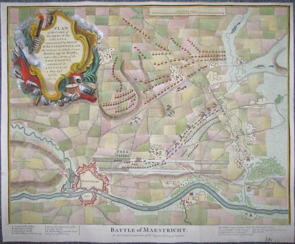
Plan of the Battle of Maastricht, 1703
Isaac Basire.

London, 1745. Fought in the War of the Spanish Succession. 'D'Auverquerque' is the Dutch General Ouwerkerk, ally of Marlborough against the French. Engraved by Basire for 'Mr. Tindal's Continuation of Mr.Rapin's History of England'.
BASI0006
£185.00

More details


Map of the Netherlands
Nicolas Sanson.

Paris, c.1692. The Netherlands, engraved by A. de Winter for the quarto edition of Sanson's atlas. The title cartouche features allegorical figures including Mercury & Neptune.
SANS0048
£150.00

More details


Decorative map of Holland
John Tallis.

London, John Tallis & Co., c.1851. With inset vignettes including a view of Rotterdam.
TALL0016
£59.00

More details


Early map of Friesland
Abraham Ortelius.

Antwerp, Jan Baptist Vrients, 1602, Spanish text edition. A map of West Friesia or Friesland, with an inset showing the region in Roman times, from a Spanish edition of the 'Theatrum Orbis Terrarum', the first edition published by Vrients.
ORTE0038
£680.00

More details


Early map of Frisia
Abraham Ortelius.

Antwerp, 1592, Latin text edition. A map of Friesland, with an inset showing the region in Roman times, from a Spanish edition of the 'Theatrum Orbis Terrarum', the first edition published by Vrients.
ORTE0039
£420.00

More details


Map of West Frisia
Willem Blaeu.

Amsterdam, 1640. West Frisland, with three fine cartouches in full colour.
BLAE0030
£250.00

More details


Map of Utrecht
George Louis Le Rouge.

Paris, c.1756.
LERO0006
£68.00

More details


Decorative map of Luxembourg in fine colour
Gerard Mercator

Amsterdam, Jodocus Hondius, 1613. Luxembourg and the district of Trier in Germany, by Gerard Mercator himself, with a strapwork title cartouche.
MERC0040
£450.00

More details


 1