Fine Antique Maps & Engravings
from the 16th to the 19th centuries
Quick search:

Advanced search
Cartographer index
Your basket:
0 items
£0.00
View basket
Americas > North America
Sort results by: Most recently added Cartographer A-Z Year printed Price, lowest to highest Price, highest to lowest Region
Chart of the Slave Trade Routes
Thomas Bowen.

London, 1788. Chart of the North Atlantic showing the routes from Europe to Africa and across the Atlantic to the West Indies and the plantations of America.
BOWE0015
£150.00

More details


Miniature Map of Arctic America
Alain Manesson Mallet.

Paris, c.1683. Greenland with Labrador and Baffin's Island.
MALL0085
£98.00

More details


Inuits of Arctic America
Volkergallerie.

Gernamny, c.1836. Fanciful portraits of Inuit.
VOLK0002
£75.00

More details


Cook's Voyage through the Bering Straits
Benard.

Paris, c.1785. Captain James Cook's third and final expedition was sent to try to find the North West Passage from the Pacific. The ship sailed though the Bering Straits to be blocked by the icewall. Turning south they sailed to Hawaii where Cook was killed. Published in a French account of Cook's Voyages.
BENA0007
£175.00

More details


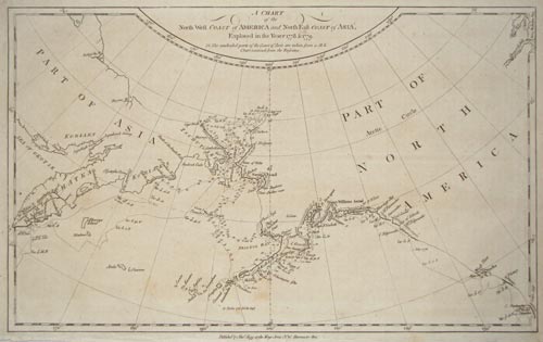
Cook's Map of the Bering Straits.
Alexander Hogg.

London: Hogg, c.1785. The purpose of Cook's Third Voyage was to discover the North West Passage. Having discovered Hawaii in January 1778 he sailed up the eastern coast of America and passed through the Bering Straits, where he was blocked by the Arctic icewall. He returned to Hawaii in 1779, where he was killed, after which his crew went north for a second attempt to breach the icewall, again failing before returning to England.
HOGG0006
£125.00

More details


View of Cook's crew shooting Walruses.
Capt. James Cook.

London, Alexander Hogg, c.1790. From 'Anderson's Large Folio Edition of the Whole of Capt.n Cook's Voyages &c Complete'.
COOK0016
£95.00

More details


 1