Fine Antique Maps & Engravings
from the 16th to the 19th centuries
Quick search:

Advanced search
Cartographer index
Your basket:
0 items
£0.00
View basket
Americas > South America
Sort results by: Most recently added Cartographer A-Z Year printed Price, lowest to highest Price, highest to lowest Region
Map of South America
John Walker.

London, 1801. Published in 'Walker's Geography'.
WALK0003
£75.00

More details


Chart of the Rio de la Plata
Jacques Nicolas Bellin.

Paris, c.1760. With Buenos Aires & Montevideo.
BELL0063
£58.00

More details


Map of Argentina and Chile
John Tallis.

London: John Tallis & Co., c.1851. Decorative map of Chile and Argentina, before the two countries expanded south into Patagonia, with decorative vignettes including a view of the Grand Square of Buenos Ayres.
TALL0063
£98.00

More details


Chart of the Le Maire Straits
Jacques Nicolas Bellin.

Paris, c.1760. The Le Maire Straits were discovered in 1616, as the Dutch explorers Jacob Le Maire and Willem Schouten were attempting to find a better route from the Atlantic to the Pacific than the dangerous Magellan Straits. They discovered Cape Horn shortly afterwards.
BELL0132
£75.00

More details


Benzoni Conquistadors
Girolamo Benzoni.

Frankfurt: Theodore de Bry, c.1596. Spanish conquistadors standing around a pile of treasure brought to them by the locals. On the left one Spaniard has his hand on his sword hilt, about to draw it.
BENZ0003
£150.00

More details


Benzoni Brazilian cannibals
Benzoni, Girolamo.

Frankfurt: Theodore de Bry, c.1596. A gruesome scene of Brazilian warriors disposing of prisoners, killing, butchering and cooking them.
BENZ0001
£200.00

More details


De Bry Warring Natives
Theodore de Bry.

Frankfurt: Theodore de Bry, c.1596. Two tribes, naked except for headdresses, fire bows at each other. On the right two Europeans join in with muskets.
DEBR0004
£200.00

More details


An early illustration of the Americas
Girolamo Benzoni.

Frankfurt: Theodore de Bry, c.1596. Spanish conquistadors mistreating American indians,.
BENZ0002
£200.00

More details


Map of Brazil
Nicolas Sanson.

Paris, c.1692. Brazil, showing the Portuguese administrative divisions on the coastline. Engraved by A. de Winter for the quarto edition of Sanson's atlas.
SANS0045
£140.00

More details


Map of Brazil
Jan Luyts.

Utrecht, 1705. Map of Brazil, with a garland title cartouche filling the interior.
LUYT0004
£195.00

More details


The Travels of Jean de Léry to Brazil
Pieter van der Aa.

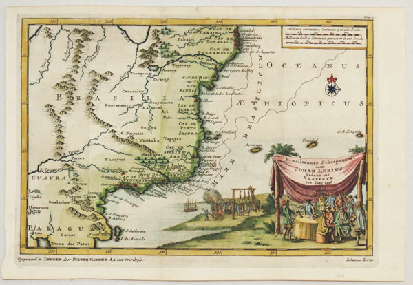
Leiden, 1707. A map of the environs of Rio de Janeiro, published to illustrate Jean de Léry's account of his experiences in Brazil as a member of the Chevalier de Villegaignon's attempt to colonise Brazil for France. de Léry (1536-1613), a Protestant, joined the expedition expecting religious freedom in the new colony of 'France Antarctique', but religion split the colony, making it easy for the Portuguese to defeat it. The title cartouche features a well-filled gallows, perhaps illustrating the religious strife. Returning to France de Léry published his 'History of a Voyage to the Land of Brazil', which van der Aa included in a collection of important voyages, with this map.
AAAA0018
£290.00

More details


Map of Brazil
Carey & Lea.

Philadelphia, 1822 or London, 1823. From the 'Complete Historical, Chronological and Geographical American Atlas'.
CARE0001
£125.00

More details


Map of southern Brazil and Uruguay
Jacques Nicolas Bellin.

Paris, c.1757. Map of Rio Grande so Sul in southern Brazil & Uruguay to the mouth of the Rio de la Plata.
BELL0012
£42.00

More details


Chilean native costume
Alain Manesson Mallet.

Paris, c.1683. A Chilean couple with their villiage in the background, published in Mallet's 'Description de l'Univers'.
MALL0119
£75.00

More details


Map of Santiago de Chile
Jacques Nicolas Bellin.

Paris, c.1756. Plan of Santiago, capital of Chile, before the construction of the Calicanto Bridge began in 1767.
BELL0189
£125.00

More details


Large, detailed map of Chile
John Pinkerton.

London, Cadell & Davies, 1809. Large and detailed map of Chile, with an inset of Juan Fernandes Island.
PINK0008
£140.00

More details


17th century map of Columbia
Johannes Jansson.

Amsterdam, c.1647. The north west part of South America, showing Costa Rica, Panama, Colombia and Venezuala as far east as Curaçao.
JANS0014
£350.00

More details


Map of Colombia and Venezuela
Nicolas Sanson.

Paris, c.1692. North-west South America, engraved by A. de Winter for the quarto edition of Sanson's atlas.
SANS0074
£175.00

More details


Colombia, with Panama
Thomas Kitchin.

London: Strahan & Cadell, 1795. From the Rev. Dr. Robertson's History of America.
KITC0013
£125.00

More details


Plan of an Incan royal palace near Cuenca, Equador.
Jacques Nicolas Bellin.

Paris, c.1755. A palace belonging to the Incan kings, with an extensive key.
BELL0188
£49.00

More details