Fine Antique Maps & Engravings
from the 16th to the 19th centuries
Quick search:

Advanced search
Cartographer index
Your basket:
0 items
£0.00
View basket
All stock
Sort results by: Most recently added Cartographer A-Z Year printed Price, lowest to highest Price, highest to lowest Region
Detailed two-sheet map of Roman Africa
Society for the Diffusion of Useful Knowledge.

London: SDUK, 1840. A pair of maps of the Roman provinces of North Africa, from Mauritania to the borders of Egypt, compiled by Philip Smith of University College London.
SDUK0087
£95.00

More details


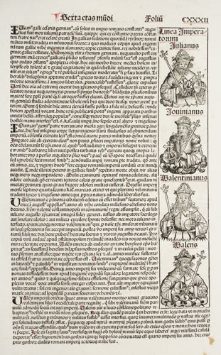
Very early printed portraits of four Roman Emperors
Hartman Schedel.

Nuremburg, 1493, Latin edition. An incunable sheet featuring four portraits of Roman emperors: Julian (sole ruler AD 361-363), Jovian (363-364), Valentinian (emperor of the West 364-375) & Valens (Eastern Roman Emperor 364-378). On the reverse are seven more woodcuts, portraits of a religious theme, including Macedonius I of Constantinople, the heretic bishop c.AD 350.
SCHE0005
£175.00

More details


Diagrammatic map of Europe
Sebastian Munster

Basle, c.1560. An interesting, distorted, diagrammatic map of Europe.
MUNS0024
£150.00

More details


 Illustration of the Creation
Sebastian Munster

Basle, c.1560, Italian text. The first page of text an Italian edition of Munster's 'Cosmography', with an account of the Creation, with an illustration with God in the upper centre, angels in the top corners and dog-headed men in the bottom corners. With a capital of a putti with the letter 'H'.
MUNS0033
£225.00

More details


Ptolemiac map of Central Asia
Girolamo Ruscelli.

Venice, 1562. Map of Central Asia after Claudius Ptolemy of Alexandria (c. AD 90-168). covering the area of modern Iran, Turkmenistan, Uzbekistan, Kasakhstan, Afghanistan, Kashmir, etc. 'Turris Lapidea' (Tower of Stone) is believed to be Tashkent.
RUSC0025
£125.00

More details


Early map of Lake Leman
Sebastian Munster

Basle, 1588. Lake Leman or Lake Geneva, orientated with north to the bottom, so Geneva is on the right of the map.
MUNS0022
£125.00

More details


Map of England & Wales after Humphrey Lhuyd
Matthias Quad.

Cologne, c.1593. Map of England, engraved by Henry Nagel, who apparently only engraved maps for the Quad series. It is derived from Welshman Humphrey Lhuyd's map as published by Ortelius in 1573, and has a Latin-text decription on the reverse.
QUAD0001
£450.00

More details


Miniature map of Brandenburg
Abraham Ortelius.

Antwerp, Plantin, 1593. Minature map of Brandenburg, centred on Berlin, engraved by Philip Galler for Ortelius's Epitome, this example for an Italian-text edition, translated by Giovanni Paulet.
ORTM0046
£75.00

More details


Miniature map of Saxony
Abraham Ortelius.

Antwerp, Plantin, 1593. Minature map of Saxony, engraved by Philip Galler for Ortelius's Epitome, this example for an Italian-text edition, translated by Giovanni Paulet.
ORTM0052
£56.00

More details


Miniature map of Westphalia
Abraham Ortelius.

Antwerp, Plantin, 1593. Minature map of Westphalia, engraved by Philip Galler for Ortelius's Epitome, this example for an Italian-text edition, translated by Giovanni Paulet.
ORTM0054
£56.00

More details


Magini Iberia
Giovanni Antonio Magini.

Venice, Galignani, 1598. A map of Spain & Portugal after Claudius Prolemy of Alexandria, showing the peninsula as known to the Romans. It marks the Straits of Hercules.
MAGI0040
£0.00

More details


Miniature map of the West Indies
Petrus Bertius.

Amsterdam, c.1600, Latin text edition. Untitled map of the West Indies, engraved by either Pieter van den Keere or Jodocus Hondius the Elder. This is the earliest of two plates used to illustrated the Bertius atlas, without longitude and latitude scales. It was replaced by a new plate by Jodocus Hondius the younger in 1616.
BERT0103
£250.00

More details


World & continents miniature set, with two World maps
Petrus Bertius.

Amsterdam, c1606, A fine set of miniature maps, consisting of two world maps (a double-hemisphere and an oval. both signed by Jodocus Hondius, and four maps of the continents. These are printed from the first set of printing plates, with the narrow borders without longitude and latitude marks.
BERT0107
£2000.00

More details


First Issue of Vrient's Miniature World Map
Jan Baptista Vrients.

Antwerp, Vrients, 1601. When Vrients published his first edition of Ortelius's Epitome he introduced this new double-hemisphere map, alongside the original oval map engraved by Galle. It is untitled, although there is 'Globus Terrestris' in letterpress above the map. Under the spheres is a rustic scene, with a church in the centre.
VRIE0001
£750.00

More details


Ortelius's map of the northern Balkans in fine colour
Abraham Ortelius.

Antwerp, Vrients, 1602, Spanish text edition. The northern Balkans, with Slovenia and Croatia, based on the map by Augustin Hirschvogel, 1565. The original hand colour is particularly fine, with the woodcut initial on verso also coloured.
ORTE0037
£650.00

More details


Miniature map of Turkish Empire
Abraham Ortelius.

Antwerp, 1602, French text edition. Miniature map of Arabia and the Turkish Empire , published in Michel Coigent's 'L'Epitome du Theatre de L'Univers d'Abraham Ortelius'.
ORTM0030
£150.00

More details


Fine map of Africa
Gerard Mercator

Amsterdam, Jodocus Hondius, 1609. Prepared by Gerard Mercator Junior for the posthumous third volume of his grandfather's atlas, this example comes from the first French edition. The title is within a superb strapwork cartouche.
MERC0001
£1600.00

More details


Fine map of Europe
Rumold Mercator.

Amsterdam, Jodocus Hondius, 1607. Prepared by Rumold Mercator for the posthumous third volume of his father Gerard Mercator's atlas, this example comes from the first French edition. The title is within a superb strapwork cartouche.
MERC0043
£980.00

More details


Fine map of Switzerland
Abraham Ortelius.

Antwerp, 1612.. Switzerland, orientated with north at the bottom of the map.
ORTE0027
£680.00

More details


Decorative Map of the East Indies
Jodocus Hondius.

Amsterdam, 1613. An early example of this map of the Far East, first issued 1606, showing from India to China & the Philippines. With two fine strapwork cartouches in full original colour.
HOND0030
£2400.00

More details


 1 2 3 4 ...Next page