Fine Antique Maps & Engravings
from the 16th to the 19th centuries
Quick search:

Advanced search
Cartographer index
Your basket:
0 items
£0.00
View basket
Americas > South America
Sort results by: Most recently added Cartographer A-Z Year printed Price, lowest to highest Price, highest to lowest Region
Map of Guiana
Guiane divisée en Guiane et Caribane.
Nicolas Sanson.

Paris, c.1692. Guyana, Surinam and French Guyiana, with the mythical Lac Parime and El Dorado. Engraved by A. de Winter for the quarto edition of Sanson's atlas.
SANS0075
£150.00

More details


Early view of Cayenne
The Prospect of the Fort and Town St Lewis At Cayanne. as it sheweth from ye Road.
Churchill.

London: Awnsham and John Churchill, 1746 View of the town of Cayenne (in present-day French Guiana) showing the fort, here named Fort Saint Lewis. A key names the Governor's House and the King's Warehouse, etc. Also shown are several native American boats or pirogues. Engraved by John Kip for Churchill's 'A collection of voyages and travels'.
CHUR0008
£95.00

More details


Map of the colony of Cayenne in French Guiana
The Island and Colony of Cayenne, Subject to the French, on the Continent of South America.
Thomas Jefferys.

London, 1760. Published during the Seven Years' War (1756-63), Cayenne was a potential target for British forces intent on driving the French from America.
JEFF0004
£250.00

More details


Chart of the Coasts of Guiana
Carte de la Guyane.
Jacques Nicolas Bellin.

Paris, 1757. The Guyanas.
BELL0025
£49.00

More details


Guyana
British Guayana.
John Tallis.

London & New York, John Tallis & Co., c.1855. Guyana map with engraved vignette scenes, including a prospect of Georgetown.
TALL0042
£75.00

More details


Important Map of the Straits of Magellan.
Exquisita & magno aliquot mensium periculo lustrata etiam retecta Freti Magellanici Facies.
Jodocus Hondius.

Amsterdam, 1623. Detailed chart of the Magellan Straits, reflecting their importance at the time, being the only known sea route from the Atlantic to the Pacific. It is decorated with three large strapwork cartouches, one each for the title, scale and coastal profile, a large compass rose over Terra del Fuego, sealions (with manes) ships and sea-monsters. A classic map.
HOND0044
£725.00

More details


Chart of the Straits of Magellan
Carte Réduite du Détroit de Magellan.
Jacques Nicolas Bellin.

Paris, c.1753. Detailed chart of the Straits. after the survey of Labat, who spent seven months in the area with Beauchesne in 1699.
BELL0102
£98.00

More details


Map of Paraguay, Uruguay and Argentina
Le Paraguay Subdivisé en ses principales parties...
Nicolas Sanson.

Paris, c.1692. Paraguay, Uruguay and Argentina. Engraved by A. de Winter for the quarto edition of Sanson's atlas.
SANS0077
£150.00

More details


Map of Uruguay
Carte de Paraguay et des Pays Voisins.
Jacques Nicolas Bellin.

Paris, 1756. Uruguay and part of Argentina, with Montevideo & Buenos Aires.
BELL0059
£85.00

More details


Map of Tierra del Fuego, with the Straits of Magellan
Extr�mit� M�ridionale de l'Amerique.
Extrémité Méridionale de l'Amerique.

Paris: 1778. With five insets, including one of Le Maire's Strait after Captain Cook, 1769.
BONN0028
£150.00

More details


Argentina map & Bolivia, Paraguay and Uruguay
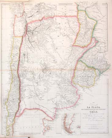
The Provinces of La Plata, the Banda Oriental del Uruguay and Chile, Chiefly from M.S. documents communicated by Sir Woodbine Parrsh, K.C.H., Late H.M. Chargé d'Affaires &c. at Buenos Ayres.
John Arrowsmith.

London, 1842. Detailed map of South America from southern Bolivia, Paraguay and Uruguay to Patagonia, with an inset of Tierra del Fuego. Issued in the 'London Atlas' by the foremost British cartographer of his generation.
ARRO0006
£150.00

More details


Miniature map of Peru
Perou.
Alain Manesson Mallet.

Paris, c.1683. Also including Ecuador.
MALL0070
£68.00

More details


Peruvian native costume
P.les du Perou.
Alain Manesson Mallet.

Paris, c.1683. Two Peruvian warriors, published in Mallet's 'Description de l'Univers'.
MALL0117
£68.00

More details


Map of southern Peru and Bolivia
Partie Meridionale du Perou.
Gilles Robert de Vaugondy.

Paris, 1749. Southern Peru and Bolivia.
ROBE0043
£58.00

More details


Detailed map of Peru
Peru.
John Cary.

London, c.1815. A colourful map of Peru.
CARY0026
£56.00

More details


Map of the Peru-Bolivian Confederation
Pérou et Bolivia.
Anonymous.

French, c.1840. A map of the short-lived Peru-Bolivian Confederation, linking the 'Republic of South Peru' with Bolivia, 1836-39. It collapsed after an invasion by Chile.
ANON0024
£35.00

More details


Map of Peru and Bolivia
Peru & Bolivia.
John Tallis.

London: London Printing and Publishing Company, c.1855. Decorative map of Peru and Bolivia, still showing the Bolivian corridor to the sea, lost during the War of the Pacific (1879-83). The decorative vignettes include views of Lima and Potosi, Bolivia's mountain of silver.
TALL0065
£89.00

More details


View of South Georgia
Possession Bay in the Island of South Georgia.
W. Hodges.

London: Strahan & Cadell, 1777. View of the glaciers on South Georgia, drawn by Hodges, the offical artist on Captain Cook's second voyage around the world.
HODG0001
£225.00

More details


Early view of South Georgia
Gezigt van Bezitneeming-Baai aan het Eiland Zuid-Georgie.
Capt. James Cook.

Amsterdam, c.1785. A view of Possession Bay on South Georgia, with the glaciers, drawn 1775. This illustration comes from a Dutch edition of the official account of Cook's Second Voyage, on which he circumnavigated the island, made the first landing, claiming the territory for Britain and naming it in honour of King George III.
COOK0021
£195.00

More details


View of Paramaribo in Suriname
View of the Town of Paramaribo, with the Road & Shipping; from the opposite Shore.
John Gabriel Steadman.

London: J. Johnson, 1794. View of Paramaribo from across the Suriname River, published in Captain Steadman's ' Expedition to Surinam, being the Narrative of a Five Year Expedition Against the Revolted Negroes of Surinam in Guiana on the Wild Coast of South America from the Year 1772 to 1777 '.
STED0001
£195.00

More details