Fine Antique Maps & Engravings
from the 16th to the 19th centuries
Quick search:

Advanced search
Cartographer index
Your basket:
0 items
£0.00
View basket
Cartographer: 'Homann Heirs.'
Sort results by: Most recently added Cartographer A-Z Year printed Price, lowest to highest Price, highest to lowest Region
Map of London & Environs
Regionis, Quae est circa Londinium...
Homann Heirs.

Nuremberg, 1741. Map of the commuter belt of London, extending to Maidenhead in the west, Luton, Chelmsford & Leatherhead. Under the map is a panorama of London showing from Westminster to the Tower.
HOMA1013
£695.00

More details


Map of Europe
Europa...
Homann Heirs.

Nuremberg, c.1743. Europe by the cartographer Johann Matthias Haas.
HOMA1031
£490.00

More details


Map of British Isles
Regnorum Magnae Britanniæ et Hiberniæ Mappa Geographica.
Homann Heirs.

Nuremberg, 1741. The British Isles with a decorative title cartouche and an inset of the Shetlands.
HOMA1004
£395.00

More details


Map of Scandinavia
Scandinavia complectens Sueciæ, Daniæ & Norwegiæ Regna.
Homann Heirs.

Nuremberg, 1776.
HOMA1019
£450.00

More details


Map of eastern Belarus
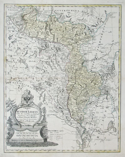
Charte von Russisch Litauen, welche die von Polen an Russland abgetretene Woiewodschaften, Liefland, Witepsk,Mscislaw, unde einen Theil der Woiewodschasten Polock und Minsk enthalt.
Homann Heirs.

Nuremburg: Homann Heirs, 1775. Map of eastern Belarus, including the the counties of Vitebsk, Polotsk and Mstislavl, seized three years earlier by the Russians in the First Partitiion of Poland. Marking the Dnieper and Dwiner rivers, with the towns of Polack, Orsha & Mogilev. Over the borders are Smolensk in Russia and Kiev in Ukraine.
HOMA1035
£450.00

More details


Chart of the Strait of Gibraltar in 1756
Carte Topographique des Pays et Côtes Maritimes Qui forment le Détroit de Gibraltar.
Homann Heirs.

Nuremberg, 1756. Chart of the Strait of Gibraltar, orientated with north to the bottom of the map, with tables to help mariners cope with the strong tidal forces. Published during the Seven Years' War, the British garrison at Gibraltar is not the focal point of the chart, but the Strait as a route to Minorca. The island's harbour, Mahon, which was a vital shelter for the British Navy, and in the year of publication of this chart the French laid seige to and took the island. An inset shows the routes of the English and French navies to the Balearics.
HOMA1034
£450.00

More details


 1