Fine Antique Maps & Engravings
from the 16th to the 19th centuries
Quick search:

Advanced search
Cartographer index
Your basket:
0 items
£0.00
View basket
Americas > United States
Sort results by: Most recently added Cartographer A-Z Year printed Price, lowest to highest Price, highest to lowest Region
French map of eastern North America
Carte de la Nouvelle France ou se voit le cours de grandes Rivieres de S. Laurens & de Mississipi...
Reiner & Josua Ottens.

Amsterdam, c.1745. A very decorative map of eastern North America, with inset map and prospect of Quebec, the foremost French settlement of the period. Another shows the Gulf coast at the mouth of the Mississippi.
OTTE0003
£2250.00

More details


Map of the European colonies of the north east
Recens Edita totius Novi Belgii, in America Septentrionale siti...
Georg Matthaus Seutter.

Augsburg: Tobias Conrad Lotter, c.1750. Seutter's German version of the Jansson-Visscher 'Nova Belgi' map, as published by his son-in-law, updated to reflect the political reality of Britain's control of the area. The view of New York is the 'Restitutio' view, celebrating the short Dutch re-occupation of the city 1673-74, but instead of Dutch allegory the cartouche shows tribute being offered to George II of Great Britain.
SEUT0043
£2400.00

More details


USA
Etats-Unis.
Jules Renouard.

Paris, 1838. Map of United States
RENO0001
£60.00

More details


Detailed map of the U.S.
United States.
Thomas Kelley.

London, Kelly, 1840. With an inset of Florida.
KELL0002
£75.00

More details


United States
États-Unis de L'Amerique du Nord.
Charles Monin.

Paris, c.1842. United States map with Texas as part of Mexico.
MONI0001
£88.00

More details


United States
États-Unis de L'Amerique du Nord.
Charles Monin.

Paris, c.1842. United States map with Texas as a republic.
MONI0002
£98.00

More details


Cook's Map of Cook Inlet
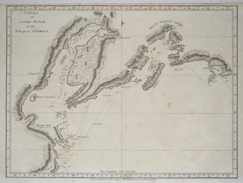
Chart of Cooks River in the N.W. part of America.
Alexander Hogg.

London: Hogg, c.1785. The purpose of Cook's Third Voyage was to discover the North West Passage. Having discovered Hawaii in January 1778 he sailed up the eastern coast of America and passed through the Bering Straits, where he was blocked by the Arctic icewall. He returned to Hawaii in 1779, where he was killed, after which his crew went north for a second attempt to breech the icewall, again failing before returning to England. In Alaska he mapped Cooks Inlet and Prince William Sound, both of which appear on this map. At the head of the inlet is 'R. Turn-again', named by William Bligh of HMS Bounty fame. Cook had sent Bligh, his sailing master, up the river, hoping it was an entrance to the North West Passage. Blight named it in frustration when he realised it was another dead-end,
HOGG0007
£95.00

More details


Alaskan Coastal Profiles, from Cook's Voyages
Gezigten der West-Kust van America.
Capt. James Cook.

Amsterdam, c.1785. Nine coastal profiles of Alaska, including Price William's South and Mt St Elias. Although he is not credited here, some were drawn by William Bligh, later captain of the Bounty, famous for the mutiny. Published in a Dutch edition of Cook's Voyages.
COOK0004
£68.00

More details


Aleutian Islands pair
Iles Aleutiennes [Sheets 38 & 39.]
Philippe Vandermaelen.

Brussels, 1827. Two sheets charting the Aleutian Islands, the chain of islands crossing the north Pacific, from Semisopotohnoi to Tanaga, marking the routes of the explorers who mapped them in the 1790s. The maps were published in the first atlas of the world on the same scale, some of the more remote areas of the world such as this are shown in unprecedented detail.
VAND0011
£250.00

More details


Harris Californians
The Inhabitants of California in their respective Dresses.
John Harris.

London, John Harris, 1744-8. Four images of Californian natives, two Pericú men fishing with a raft and harpoon, and two women, one with a bow. Published in 'Navigantium atque Itinerantium Bibliotheca'.
HARR2001
£95.00

More details


La Perouse Promerops

Jean François Galoup La Pérouse.

Jean François Galoup La Pérouse. The California Thrasher, drawn by Prevost for the account of La Pérouse's scientific expedition to the Pacific.
LAPE0005
£140.00

More details


La Perouse Partridge
Male & Female Partridge of California.
Jean François Galoup La Pérouse.

London, G.G. & I. Robinson, 1798. A pair of Californian Partridges, drawn by de Vaney for the account of La Pérouse's scientific expedition to the Pacific.
LAPE0007
£195.00

More details


Portraits of Californian natives.
Tanz der Indianer auf Californien. Thurm der altamerikanischen Stadt Tlapallan.
Georg Heinrich von Langsdorff.

c.1835. A version of Langsdorff's drawing of dancing Indians at the Mission in San Jose, New California, and a view of an Aztec tower. Published in the 'Vollstandige Volkergallerie',
LANG2001
£75.00

More details


View of Hartford, Connecticut
Hartford, Connecticut.
John Tallis.

London: J.F. Tallis, c.1851. Hartford, Connecticut. The decorative borders have two historical scenes: Captain Wadsworth hiding the Constitution charter in the fanous oak in 1687; and Governor Fletcher's authority resisted by the Militia, 1683.
TALL0062
£39.00

More details


Dakota & Manitoba
Tunison's North Dakota and Part of Manitoba, Canada; Tunison's South Dakota.
Tunison.

American, c.1890. Map of Dakota & Manitoba The Battle of Little Big Horn (1876) is commemorated by Custer County, Custer City and Custer Peak.
TUNI0001
£98.00

More details


Map of the District of Columbia
District de Columbie.
Jean Alexandre C Buchon.

Paris, 1825. Map of the District of Columbia, with a plan of the layout of Washington. Published in the 'Atlas Géographique des Deux Amériques', the map is surrounded by descriptive text in French.
BUCH0001
£380.00

More details


Miniature Portrait of Natives of Florida
P.les de la Floride.
Alain Manesson Mallet.

Paris, 1683 The dress of the native Floridians.
MALL0022
£125.00

More details


 Uncommon chart of Pensacola
Piano del Porto, e degli Stabilimenti Pensacola.
Viol. Vianni.

Livorno, 1763. From the 'Gazzetiere Americano'.
GAZZ0001
£350.00

More details


Cook Hawaiian Mask
A Man of the Sandwich Islands, Masked.
Capt. James Cook.

London, c.1780.
COOK0011
£125.00

More details


Hawaii Atooi
Binnengezigt van het Eiland Atooi.
John Webber.

Germany, c.1790. A view of Waimea, Atooi (Kauai) in Hawaii drawn during Captain Cook's visit 19-23 January 1778. His men can be seen trading with the natives. Cook reported that they took on board nine tons of water and 'sixty or eighty pigs'. From a German edition of Cook's voyages.
WEBB0002
£195.00

More details