Fine Antique Maps & Engravings
from the 16th to the 19th centuries
Quick search:

Advanced search
Cartographer index
Your basket:
0 items
£0.00
View basket
Europe > Germany
Sort results by: Most recently added Cartographer A-Z Year printed Price, lowest to highest Price, highest to lowest Region
Holstein & Hamburg
A Map of the Dutchy of Holstein, with the Territories of the Imperial Towns Hamburg & Lübek, Also the Bishoprick of Eutin, Laid down from Fischer's Map and Corrected by B._.
James Wyld.

London, 1875. Large and detailed map, shortly after the acquisition of Holstein by Bismark.
WYLD0008
£98.00

More details


Map of the Environs of Hamburg
Typus Geographicus Ducat. Lauenburgici Novus...
Johann Baptist Homann.

Nuremberg, 1729. The environs of Hamburg, with an allegorical cartouche featuring the bombardment of a city.
HOMA0065
£225.00

More details


Map of Maintz
Nova et accurata Moguntini Archbiepiscopatus delineatio.
Johannes Jansson.

Amsterdam, 1657. Maintz, orientated with north to the left, marking Frankfurt and Heidelberg. The title cartouche features putti and grapes.
JANS0031
£200.00

More details


Munich Plan
Plan of the City of Munich.
John Stockdale.

London, 1800. Map of Munich with a 52-point key and a decorative title cartouche.
STOC0005
£140.00

More details


Townplan of Nuremburg
Geometrisscher Grund-Riss, des h. Romischen Reichs Freyen Stadt Nurnburg.
Christoph Weigel.

Nuremburg, 1718. Detailed townplan of the cartographer's home city, with extensive keys.
WEIG0023
£350.00

More details


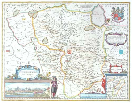
Map of Osnabruck with cartouche & armorials
Osnabrugensis Episcopatus. Auctore Ioanne Gigante.
Willem Blaeu.

Amsterdam, c.1630, blank verso. The region around Osnabrück, decorated with a title cartouche featuring a prospect of the city, an inset map, dedication cartouche and armorials. This map was one of Blaeu's first atlas maps, appearing in his first Appendix in 1630: certainly the blank verso of this example points to a pre-atlas issue.
BLAE0064
£295.00

More details


Saxony & Hamburg
Il Circolo della Bassa Sassonia...
Antonio Zatta.

Venice, 1780. Map of lower Saxony, with Hamburg marked 'Harburg'.
ZATT0044
£98.00

More details


Upper Saxony & Berlin
Parte Settentrionale del Circolo dell'Alta Sassonia.
Antonio Zatta.

Venice, 1780. Map of upper Saxony, with Berlin marked.
ZATT0049
£98.00

More details


Miniature map of Upper Saxony
Cercle de Haute Saxe.
Alain Manesson Mallet.

Paris, 1683. Map of Upper Saxony in Germany, marking Berlin, Brunswick & Meissen, published in Mallet's 'Description de l'Univers'.
MALL0124
£75.00

More details


Stormarn, southern Holstein, centred on Hamburg.
Tabula Geographica novissima Ducatus Stormariæ, in Meridionali parte Holsatiæ.
Johannes Jansson.

London: Moses Pitt, c.1680. Stormarn, southern Holstein, centred on Hamburg.
JANS0048
£240.00

More details


Miniature map of Swabia
Cercle de Souabe.
Alain Manesson Mallet.

Paris, 1683. Map of Swabia in Germany, marking Stuttgart, Baden-Baden, Ulm, Augsburg & Fugger, published in Mallet's 'Description de l'Univers'.
MALL0123
£68.00

More details


Map of Wurttemberg
...Provincia Briscoia...
Johann Baptist Homann.

Nuremberg, c.1718. South west Germany, marking Freiburg, Koblenz and Basel.
HOMA0034
£160.00

More details


Homann Gdansk
Prospect, Grundris und Gegend der Polnischen vesten Reichs und Handels-Stadt Dantzig und ihren Werder.
Johann Baptist Homann.

Nuremberg, c.1720. A map of the environs of Gdansk, with a prospect underneath, flanked with figures representing the culture and wealth of the city.
HOMA0039
£980.00

More details