Fine Antique Maps & Engravings
from the 16th to the 19th centuries
Quick search:

Advanced search
Cartographer index
Your basket:
0 items
£0.00
View basket
Europe > Scandinavia
Sort results by: Most recently added Cartographer A-Z Year printed Price, lowest to highest Price, highest to lowest Region
Map of Scandinavia
Tabula exactissima Regnarŭ Sueciæ et Norwegiæ nec non Maris Universi Orientalis...
Matthaus Merian.

Frankfurt, 1646. Decorative map of Scandinavia, with a large title cartouche.
MERI0012
£425.00

More details


Map of Sweden, Norway & Finland
Royaumes de Suede et deNorwege.
Didier Robert de Vaugondy.

Paris, 1748. Robert de Vaugondy's smaller format map of northern Scandinavia.
ROBE0046
£125.00

More details


Map of Scandinavia
Scandinavia complectens Sueciæ, Daniæ & Norwegiæ Regna.
Homann Heirs.

Nuremberg, 1776.
HOMA1019
£450.00

More details


Large map of Northern Europe
The Second Part of Europe Containing denmark, Norway, Sweden, and Russia; Drawn from D'Anville's Two-Sheet Map.
Jean Baptiste Bourguigon d'Anville.

London, John Harrison, 1788. A large and colourful map of Scandinavia, the Baltic and Russia. Iceland appears in an inset.
ANVI0001
£450.00

More details


Scandinavia
Scandinavia.
John Pinkerton.

London, Cadell & Davies, 1809. Large and detailed map of Scandinavia, with strong original colour.
PINK0009
£125.00

More details


Map of Sweden & Norway
Sweden & Norway.
John Arrowsmith.

London, 1842. Detailed map, issued in the 'London Atlas' by the foremost British cartographer of his generation.
ARRO0013
£125.00

More details


Detailed map of Sweden & Norway
Sweden & Norway
John Tallis.

London, J. & F. Tallis, c.1851. With inset vignettes including views of Stockholm and skiing.
TALL0044
£125.00

More details


Detailed map of Sweden & Norway
Schweden und Norwegen.
C.F. Weiland.

Weimar, 1853.
WEIL0001
£98.00

More details


Danish Costume
Dannois.
Alain Manesson Mallet.

Frankfurt, 1686. A Dane and his wife, from a German edition of Mallet's 'Description de l'Univers'.
MALL0079
£35.00

More details


Map of Jutland in Denmark
Jutiæ Tabula...
Frederick de Wit.

Amsterdam, c.1690. Northern Denmark, with fine title and scale cartouches and scale cartouches in full colour.
DEWI0002
£250.00

More details


Cary Denmark
A New Map of the Kingdom of Denmark, comprehending North and South Jutland, Zeeland, Fyen, Laaland, and Part of Holstein.
John Cary.

London, 1819. A detailed map, in fine colour.
CARY0014
£98.00

More details


Map of Denmark
Denmark.
John Arrowsmith.

London, 1842. Detailed map of Denmark, issued in the 'London Atlas' by the foremost British cartographer of his generation. Schleswig & Holstein are still part of the country.
ARRO0012
£95.00

More details


Map of Denmark
Map of the Kingdom of Denmark Including the Dutchies of Holstein & Lauenburg.
James Wyld.

London, c.1872. A large and colourful map.
WYLD0011
£95.00

More details


Plan of Copenhagen
Copenhague, Ville Capitale du Royaume de Dannemarq et Sejour ordinaire du Roy.
Nicolas De Fer

Paris, 1700. Plan of Copenhagen.
DEFE0008
£250.00

More details


Early representation of Inuit of Greenland
Groenlandois.
Alain Manesson Mallet.

Paris, c.1683. An Inuit couple and child, wrapped in furs. Underneath is a scene of a Inuk in a kayak about to spear a seal.
MALL0088
£49.00

More details


Greenland Inuit
Habits of the Groenlanders.
Middleton.

London, c.1780. The Inuit of Greeland, within a decorative engraved boder, published in 'Middleton's Complete System of Geography'.
MIDD0002
£89.00

More details


A Greenland Canoe.
Canoes used by the Groenlanders.
Brown.

n.d., c.1800. A large canoe, engrave by Brown.
BROW0001
£69.00

More details


Seutter Finland
Magni Ducatus Finlandiæ Russiæ partim, partim Sueciæ subjecti; Sinus item Bothnici ac Finnici nova et accurata delineatio...
Georg Matthaus Seutter.

Augsburg, c.1730. A large map of Finland, with the Gulfs of Bothnia and Finland, decorated with a title cartouche featuring Roman gods and allegorical figures.
SEUT0042
£560.00

More details


Costume plate of a Finnish girl
Habit of a Finland Girl in 1768. The above Figures was drawn by J.B. Le Prince.
Jean-Baptiste Le Prince.

London: c.1790. A costume plate depicting a Finnish country girl, after Jean-Baptiste Le Prince (1734-81).
PRIN0001
£89.00

More details


Map of the Finland/Sweden border
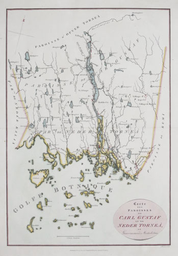
Carte des Paroisses de Carl Gustaf et de Neder Tornea en Gouvernement de Westrobotnie.
H. Mutlow.

London: Cadell & Davies, 1817. Map of the Finnish/Swedish borders, centred on Tornio, a town on the river Torne in Lapland, often a staging post for expeditions into the European Arctic. Although Tornio is on the west bank of the river Torne, the river that marks the Finnish/Swedish border, the town is part of Finland. After the 1808 war between Sweden and Russia, in which the Russians gained Finland, the new border was altered to include the town on the Russian side on the insistence of the Russian tzar.
MUTL0001
£85.00

More details