Fine Antique Maps & Engravings
from the 16th to the 19th centuries
Quick search:

Advanced search
Cartographer index
Your basket:
0 items
£0.00
View basket
Asia > Far East
Sort results by: Most recently added Cartographer A-Z Year printed Price, lowest to highest Price, highest to lowest Region
Decorative Map of the East Indies
India Orientalis.
Jodocus Hondius.

Amsterdam, 1613. An early example of this map of the Far East, first issued 1606, showing from India to China & the Philippines. With two fine strapwork cartouches in full original colour.
HOND0030
£2400.00

More details


Map of the East Indies
Les Vrays Indes dits Grand Indes ou Indes Orientales.
Nicolas De Fer

Paris, 1705. Map of India and Indochina.
DEFE0025
£390.00

More details


Map of the East Indies
The East Indies distinguishing the Empires and Kingdoms on the Continent commonly call'd India: by the S.r Robert with improvements.
Didier Robert de Vaugondy.

London, c.1760. Map of India and Indo-China with a decorative rococo title cartouche.
ROBE0047
£175.00

More details


East Indies
Indie Orientale di Qua e di la Dal Gange col loro Arcipelago. Indie IIIș Foglio.
Antonio Zatta.

Venice, c.1785. One sheet only of a four-sheet map of the East Indies, showing Formosa and the northern Philippines. With the title cartouche.
ZATT0018
£240.00

More details


Map of Tartary
Chinese and Independent Tartary.
John Cary.

London, c.1830. A colourful map of Central Asia from the Caspian Sea to Manchuria, including Mongolia, Tibet and Bokara.
CARY0023
£95.00

More details


Map of the the Russian Empire in Asia
Russia in Asia.
John Tallis.

London, John Tallis & Co, c.1851. Northern Asia, with Siberia and Kamchatka. With four vignettes.
TALL0057
£98.00

More details


Town plan of Khum Peam Lvek in Cambodia
Eauweck Capitale de Camboye.
Jacques Nicolas Bellin.

Amsterdam, 1761. From a Dutch edition of Bellin's atlas.
BELL0144
£95.00

More details


Early map of China
China Veteribus Sinarum Regio nunc Incolis Tame dicitur.
Johannes Jansson.

Amsterdam, 1647. China, Japan and the northern Philippines, with Korea shown as an island.
JANS0012
£1500.00

More details


Chart of the environs of Xiamen, China
A Chart of the Bay of Chin-Chew in China. from Montanus.
G. Child.

London: Thomas Salmon, 1747. A map of the environs of Xiamen & Zhangzhou, published in the 'Universal Traveller'. Nieuhof describes the place: 'The place is small, but well-built, has a wealthy suburb, and drives a great trade. The revenue arising from the custom paid by vessels is very considerable'.
CHIL0001
£150.00

More details


View of the Imperial Observatory at Peking.
Observatoire de Peking. tiré du Pere le Comte.
Jacques Nicolas Bellin.

Paris, c.1750. Showing globes, astrolabes and armillary spheres. The Peking Observatory was equipped by Ferdinand Verbiest, a Flemish Jesuit missionary in Peking in the late 1660s. Rather than building the latest models he worked from Tycho Brahe's 'Mechanica', published eighty years before.
BELL0113
£150.00

More details


Chart of the environs of Xiamen, China
Carte de la Baye de Chin-Chew ou Chang-Chou Avec les Isles d'Amowi et de Quemowi.
Jacques Nicolas Bellin.

Paris, c.1750. A map of the environs of Xiamen & Zhangzhou.
BELL0185
£150.00

More details


Map of Chinese Tartary, with the Silk Road, Great Wall of China & Tibet.
Carte de l'empire de Hya et Partie de Tangut...
Jacques Nicolas Bellin.

The Hague, c.1760. Engraved by Schley for a Dutch edition of Prevost, illustrating the story of Gengis Khan.
BELL0135
£125.00

More details


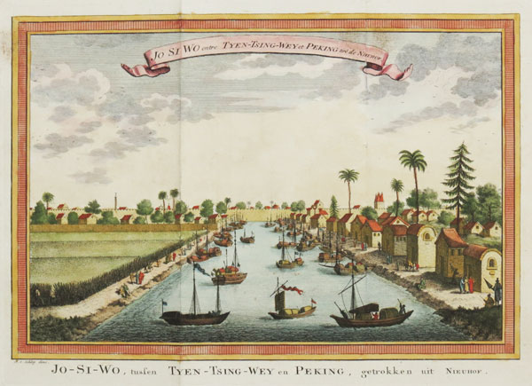
View of the Chinese city Jo-Si-Wo
Jo Si Wo entre Tyen-Tsing-Wey et Peking, tiré de Nieuhof.
Jacques Nicolas Bellin.

Paris, c.1760. A view of Jo Si Wo after Nieuhof, here engraved by Schley for a Dutch edition of the Bellin/Prévost 'Histoire des Voyages'. Nieuhof describes the place: 'The place is small, but well-built, has a wealthy suburb, and drives a great trade. The revenue arising from the custom paid by vessels is very considerable'.
BELL0186
£150.00

More details


Map of China, Korea and Japan
Carte de L'Empire de la Chine, de la Tartary Chinoise, et du Royaume de Corée; avec les Isles du Japon.
Rigobert Bonne.

Paris, c.1780. China, Korea and Japan, with the northern Philippines.
BONN0041
£125.00

More details


A Chinese bridge
View of the Flying Bridge, over the River Whang-Ho in China.
Middleton.

London, c.1780. A high bridge above a river, believed to be in Shensi province.
MIDD0005
£75.00

More details


A costume plate of a Chinese lady
Habit of a Chinese Lady, from du Halde.
J. Hall

London, 1781. 'Engraved for the Geographical Dictionary'.
HALL1002
£98.00

More details


A Chinese street trader
Toyman. Shuttlecock Playing.
A. Freschi.

London: J.J. Stokdale, 1812. A illustration of a Chinese street trader with children kicking a shuttlecock into the air. It was engraved by Freschi for an English edition of Jean-Baptiste Joseph Breton de la Martinier's 'China: Its Costume, Arts, Manufactures, &c.'.
FRES0001
£60.00

More details


Prospect of the European settlement at Canton
Vuë de Quang-Cheu-Fu ou Canton.
Jacques Nicolas Bellin.

Paris, 1748. An early view of Canton (Guangzhou) from the sea. with the harbour full of European ships.
BELL0197
£98.00

More details


View of the Porcelain Tower, Nanjing
A Prospect of the Porcelane Tower at Nan King in China.
Millar.

London, c.1785. The famous Porcelain Tower of Nanjing, built from porcelain bricks during the Ming dynasty in the 15th century. Destroyed in 1856, during the Taiping Rebellion, there are currently plans to rebuild it. Engraved by Sparrow for 'Millar's New Complete & Universal System of Geography'.
MILL0006
£98.00

More details


View of Nanking with a Pagoda
VĂŒe de Nanking tirĂ©e de Nieuhof.
Johan Nieuhof.

Paris, 1748. Johan Nieuhoff (1618-72) was a Dutch traveler who made a trip of 2,400 km from Canton to Peking in 1655-1657. His account, published 1665, was the most authoritative description of China. This example was published for Prevost's 'Histoire Generale des Voyages'.
NIEU0001
£95.00

More details