Fine Antique Maps & Engravings
from the 16th to the 19th centuries
Quick search:

Advanced search
Cartographer index
Your basket:
0 items
£0.00
View basket
All stock
Sort results by: Most recently added Cartographer A-Z Year printed Price, lowest to highest Price, highest to lowest Region
French map of eastern North America
Reiner & Josua Ottens.

Amsterdam, c.1745. A very decorative map of eastern North America, with inset map and prospect of Quebec, the foremost French settlement of the period. Another shows the Gulf coast at the mouth of the Mississippi.
OTTE0003
£2250.00

More details


Roman Britain
Robert Morden.

London, 1747? Roman Britain map, from a late issue of Morden's map(?).
MORD0023
£98.00

More details


Map of Sweden, Norway & Finland
Didier Robert de Vaugondy.

Paris, 1748. Robert de Vaugondy's smaller format map of northern Scandinavia.
ROBE0046
£125.00

More details


Scenes from Genesis
John Hinton.

London, 1749. Five scenes from Genesis, the first book of the Bible: Adam naming the animals; Eve being made from Adam's rib; their temptation by the serpent and their eviction from Eden; Cain and Abel; and the founding of Zion, the city of Enoch.
HINT0004
£85.00

More details


Map of British Isles
Homann Heirs.

Nuremberg, 1741. The British Isles with a decorative title cartouche and an inset of the Shetlands.
HOMA1004
£395.00

More details


Miniature map of South Wales
Thomas Kitchin or Thomas Jeffreys

London, 1749+. A miniature map of South Wales, engraved by either Thomas Kitchin or Thomas Jeffreys for the 'Small English Atlas', with three columns of engraved text detailing the major towns.
KITC1038
£150.00

More details


Map of the European colonies of the north east
Georg Matthaus Seutter.

Augsburg: Tobias Conrad Lotter, c.1750. Seutter's German version of the Jansson-Visscher 'Nova Belgi' map, as published by his son-in-law, updated to reflect the political reality of Britain's control of the area. The view of New York is the 'Restitutio' view, celebrating the short Dutch re-occupation of the city 1673-74, but instead of Dutch allegory the cartouche shows tribute being offered to George II of Great Britain.
SEUT0043
£2400.00

More details


Turkish Empire with Greece, Arabia and Libya
Tobias Conrad Lotter.

Augsburg, c.1750. Map of the Turkish Empire, covering Greece, Arabia and Libya.
LOTT0016
£425.00

More details


Map of England and Wales
Isaak Tirion.

Amsterdam, c.1750. England and Wales, divided into counties.
TIRI0018
£225.00

More details


Double-hemisphere world map
N. Jonge.

Copenhagen, Jonge, c.1760. Double-hemisphere world map, with the title on a banner.
JONG0001
£340.00

More details


Map of the East Indies
Didier Robert de Vaugondy.

London, c.1760. Map of India and Indo-China with a decorative rococo title cartouche.
ROBE0047
£175.00

More details


Decorative map of the British Isles
Mathias Albert Lotter.

Augsburg, T.C.Lotter, c.1764. A map of the British Isles decorated with an ornate title cartouche and the arms of England, Wales & Scotland, engraved by Mathias Lotter for his father Tobias's atlas. With good, bright colour.
LOTT0003
£390.00

More details


Crepy Maritime Flags
Crépy

Paris: Crépy, c.1767. A table of 192 flags of the navies of the world, including Britain, New England, Knights of Malta, Russia and the Ottoman Empire. Usefully a group of six flags underneath show the engraving codes for the colours.
CREP0007
£50.00

More details


A Plan for Post-Fire London
John Evelyn.

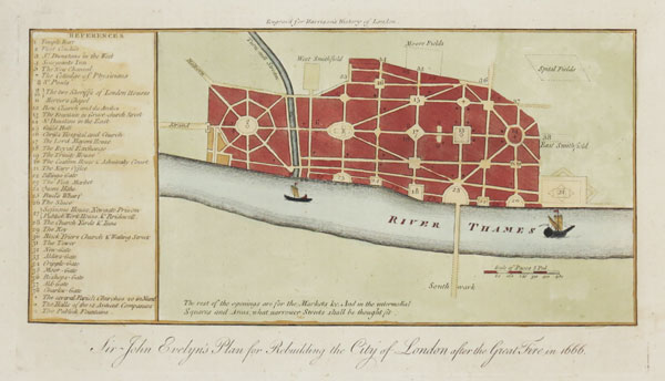
London, c.1776. After the disastrous fire of 1666 both Christopher Wren and John Evelyn submitted comprehensive plans for the rebuilding of London. This plan shows Evelyn's attempts to promote a linear road system, with regular open junctions suitable for markets, marked with a 38-point key. However both schemes failed, due to the nightmare of private ownership, astronomic cost predictions and the need to get the City operational as soon as possible. Published in 'Harrison's History of London'.
EVEL0001
£150.00

More details


Map of Scandinavia
Homann Heirs.

Nuremberg, 1776.
HOMA1019
£450.00

More details


Map of Central Asia
Rigobert Bonne.

Paris, c.1780. Central Asia from the Persian Gulf to Bhutan, marking Bahrain, the Caspian Sea, Afghanistan, Bukhara and Tibet.
BONN0036
£85.00

More details


East Indies
Antonio Zatta.

Venice, c.1785. One sheet only of a four-sheet map of the East Indies, showing Formosa and the northern Philippines. With the title cartouche.
ZATT0018
£240.00

More details


Large map of Northern Europe
Jean Baptiste Bourguigon d'Anville.

London, John Harrison, 1788. A large and colourful map of Scandinavia, the Baltic and Russia. Iceland appears in an inset.
ANVI0001
£450.00

More details


Large map of Western Europe
Jean Baptiste Bourguigon d'Anville.

London, John Harrison, 1788. A large and colourful map of Western Europe. Th Shetlands and Faroes appear in an inset.
ANVI0003
£350.00

More details


Chart of the Slave Trade Routes
Thomas Bowen.

London, 1788. Chart of the North Atlantic showing the routes from Europe to Africa and across the Atlantic to the West Indies and the plantations of America.
BOWE0015
£150.00

More details