Fine Antique Maps & Engravings
from the 16th to the 19th centuries
Quick search:

Advanced search
Cartographer index
Your basket:
0 items
£0.00
View basket
Cartographer: 'Seutter, Georg Matthaus.'
Sort results by: Most recently added Cartographer A-Z Year printed Price, lowest to highest Price, highest to lowest Region
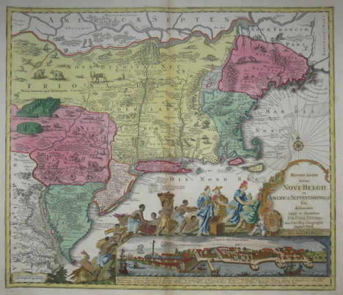
Map of the European colonies of the north east
Georg Matthaus Seutter.

Augsburg: Tobias Conrad Lotter, c.1750. Seutter's German version of the Jansson-Visscher 'Nova Belgi' map, as published by his son-in-law, updated to reflect the political reality of Britain's control of the area. The view of New York is the 'Restitutio' view, celebrating the short Dutch re-occupation of the city 1673-74, but instead of Dutch allegory the cartouche shows tribute being offered to George II of Great Britain.
SEUT0043
£2400.00

More details


Seutter Finland
Georg Matthaus Seutter.

Augsburg, c.1730. A large map of Finland, with the Gulfs of Bothnia and Finland, decorated with a title cartouche featuring Roman gods and allegorical figures.
SEUT0042
£560.00

More details


The Straits of Gibraltar
Georg Matthaus Seutter.

Augsburg, c.1730. A superbly decorative map of Straits of Gibraltar, outlining the defences of the British fortress. Under the map are prospects of the fortress, Cadiz and Malaga, and insets plans of Minorca (also held by the British) and the Spanish fortress of Ceuta (the other 'Pillar of Hercules'). The map also has a splendid martial-themed title cartouche.
SEUT0020
£680.00

More details


The Holy Land & the Peregrinations
Georg Matthaus Seutter.

Augsburg, c.1730. The Holy Land, with an elaborate title cartouche depicting Jesus expelling the demon from the possessed man, and an inset map of the Peregrinations with a portrait of Moses.
SEUT0031
£390.00

More details


Map of the Tyrol
Georg Matthaus Seutter.

Augsburg, c.1750. The mountainous borders of Italy, Switzerland & Austria, with an allegorical title cartouche lower right.
SEUT0023
£295.00

More details


 1