Fine Antique Maps & Engravings
from the 16th to the 19th centuries
Quick search:

Advanced search
Cartographer index
Your basket:
0 items
£0.00
View basket
Cartographer: 'Levasseur, Victor.'
Sort results by: Most recently added Cartographer A-Z Year printed Price, lowest to highest Price, highest to lowest Region
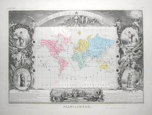
Set of maps of the World & 6 Continents
Victor Levasseur.

Paris, c.1845. A fine set, each map with bright body colour on the maps, within a highly decorative engraved border, with vignettes of views, costumes and animals. Published in one of the last decorative atlases, the 'Atlas Universel Illustré', which, unlike earlier sets, has grouped the East Indies, Australasia and the Pacific on one plate, 'Océanie'. On the map of the Americas Texas is a republic: the population table gives it a population of only 200,000.
LEVA0014
£1250.00

More details


World map on Mercator's Projection
Victor Levasseur.

Paris, c.1850. The World on Mercator's Projection, with ornate vignette borders.
LEVA0012
£195.00

More details


Map of Napoleon Bonaparte's birthplace
Victor Levasseur.

Paris, c.1845. Detailed map of Corsica, surrounded with vignettes, including portraits of Napoleon, Paoli and Loetitia, and examples of the produce of the island, from the 'Atlas National Illustré'.
LEVA0003
£95.00

More details


Map of the Hautes-Pyrénées with vignette borders
Victor Levasseur.

Paris, c.1845. Detailed map of Hautes-Pyrénées, surrounded with vignettes, including portraits of Barrere & Larrey, local dress, bear-shooting and examples of the produce of the departement. Published in the 'Atlas National Illustré'.
LEVA0015
£60.00

More details


 1